
详解iOS集成GoogleMap(定位、搜索)

简介:
最近花了些时间看了GoogleMap官方文件并集成到国际版app中,网上关于GoogleMap for iOS的讲解相对Android来说少一点,比较有帮助的几乎全是英文文档。下面是我开发过程中遇到的坑、以及采用的解决方法。
集成GoogleMap步骤:
- 1、Cocoapods导入pod 'GoogleMaps'
- 2、获取API密匙(前提是已经在GoogleMapSDK中创建好自己的应用)
- 3、配置plist文件搭建定位环境
- 4、调用代理方法实现需求
tips:pod 'GoogleMaps'、pod 'GooglePlaces'、pod 'GooglePlacePicker'这三个框架。(GoogleMaps:显示基本的定位功能;GooglePlaces:实现搜索功能,官方文档叫做地点自动完成;GooglePlacePicker:是实现获取某个POI的的详细信息,比如名字、详细地址、路线等)
景点(POI)包括公园、学校和政府大楼,等等。 另外,如果地图类型为 kGMSTypeNormal,商家景点默认将显示在地图上。 商家景点表示商店、餐馆和酒店之类的商家。
按照 Google Places API 中的定义,一个 POI 对应于一个地点。 例如,休闲公园为景点,但喷泉之类的地点通常不属于景点(除非它们具有国家或历史意义)。
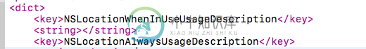
配置plist文件:
打开plist的代码源文件,输入:
定位:
一、在AppDelegate 头文件 导入框架
#import
二、向您的 application:didFinishLaunchingWithOptions: 方法添加以下内容,使用我们刚才获取到的 API 密钥替代 YOUR_API_KEY:
[GMSServices provideAPIKey:@"YOUR_API_KEY"];
tips:这一步是在启动app的时候,GoogleMap准备代理工作。
三、在我们需要显示地图的控制器调用API方法
@property (nonatomic,strong) CLLocationManager *locationManager;//地图定位对象
@property (nonatomic,strong) GMSMapView *mapView;//地图
@property (nonatomic,strong) GMSMarker *marker;//大头针
@property (nonatomic,strong) GMSPlacesClient * placesClient;//可以获取某个地方的信息
//注册的代理
@interface TestMapViewController ()
tips:这是在控制器.h文件声明的属性。
(一)初始化一个地图对象
GMSMapView:是控制地图的外观类
GMSCameraPosition:是控制地图要显示的内容类
GMSCameraPosition *camera = [GMSCameraPosition cameraWithLatitude:-23.12960481 longitude:113.30887721            zoom:Level];
 self.mapView = [GMSMapView mapWithFrame:CGRectZero camera:camera];
 self.mapView.delegate = self; //注册代理属性
 self.mapView.settings.compassButton = YES;//显示指南针
 [self.view addSubview:self.mapView];
tips:上面的经纬度可以随便传一个,之后会获取到新的经纬度并更新位置
(二)初始化一个定位管理者对象
if (self.locationManager == nil) {
  self.locationManager = [[CLLocationManager alloc]init];
 }
 self.locationManager.delegate = self;
 [self.locationManager requestAlwaysAuthorization];//授权方式,如果在后台也需要定位,那就选择 requestAlwaysAuthorization。
 self.locationManager.desiredAccuracy = kCLLocationAccuracyBest;//最精确的定位
 self.locationManager.distanceFilter = kCLDistanceFilterNone; // 默认是kCLDistanceFilterNone,也可以设置其他值,表示用户移动的距离小于该范围内就不会接收到通知
 [self.locationManager startUpdatingLocation];
tips:CLLocationManager 是负责获取用户行为的类,列如获取用户当前位置信息。更多详细信息请阅览CLLocationManager。里面讲解CLLocationManager的一些应用场景并有代码实例。
运行app:这时候我们会看到并没有实景地图出来,原因是:前面提到的GMSCameraPosition类,我们并没有在定位成功之后将定位内容赋它。
GMSCameraPosition类,它是负责显示定位内容的。很重要!
(三)在定位成功的API代理方法中,获取经纬度并转成影像赋值
- (void)locationManager:(CLLocationManager *)manager didUpdateLocations:(NSArray *)locations{
 CLLocation *curLocation = [locations lastObject];
 // 通过location 或得到当前位置的经纬度
 CLLocationCoordinate2D curCoordinate2D = curLocation.coordinate;
 GMSCameraPosition *camera = [GMSCameraPosition cameraWithLatitude:curCoordinate2D.latitude longitude:curCoordinate2D.longitude zoom:Level];
 CLLocationCoordinate2D position2D = CLLocationCoordinate2DMake(curLocation.coordinate.latitude, curLocation.coordinate.longitude);
 self.mapView.camera = camera;//这句话很重要很重要,将我们获取到的经纬度转成影像并赋值给地图的camera属性
 [self.locationManager stopUpdatingLocation];//定位成功后停止定位
}
tips:locationManager: didUpdateLocations: 代理方法是GoogleMap 中实现定位成功后回调的代理方法,你可以在这里获取到经纬度。
运行app:这时候地图就出来了
添加大头针
GMSMarker类是负责显示大头针,默认是红色,你可以自定义大头针,用图片或者改变颜色,具体看官方文档GMSMarker。
 self.marker = [GMSMarker markerWithPosition:position2D];
 self.marker.map = self.mapView;
tips:position2D是在定位成功之后转换得到的CLLocationCoordinate2D属性经纬度值。
小坑提示:这时候有可能会出现,定位成功之后出现多个大头针。原因是:进行定位的时候,map获取多个预测位置,从而产生生成多个大头针的现象。解决办法:在每次生成大头针之前先清除之前的那个,只生成最精准的最后一个。
[self.marker.map clear];
 self.marker.map = nil;
反编码(经纬度转成具体位置):
 CLGeocoder *geocoder = [[CLGeocoder alloc]init];
 //反地理编码
 [geocoder reverseGeocodeLocation:curLocation completionHandler:^(NSArray * _Nullable placemarks, NSError * _Nullable error) {

  if (error) {
  }else{

    CLPlacemark *placemark = [placemarks objectAtIndex:0];//第一个位置是最精确的
    //赋值详细地址
    DLog(@"placemark---路号name:%@-市locality:%@-区subLocality:%@-省administrativeArea:%@-路thoroughfare:%@",placemark.name,placemark.locality,placemark.subLocality,placemark.administrativeArea,placemark.thoroughfare);

  }];
这时候就已经可以获取到具体的国家、省、市、区、街道了。
补充:反编码是获取不到POI位置的(我获取不到)。这时候可以使用
self.placesClient = [GMSPlacesClient sharedClient];//获取某个地点的具体信息
 [self.placesClient currentPlaceWithCallback:^(GMSPlaceLikelihoodList *likelihoodList, NSError *error) {
  if (error != nil) {
   DLog(@"Current Place error %@", [error localizedDescription]);
   return;
  }

//  for (GMSPlaceLikelihood *likelihood in likelihoodList.likelihoods) {
//   GMSPlace* place = likelihood.place;
//   NSLog(@"Current Place name %@ at likelihood %g", place.name, likelihood.likelihood);
//   NSLog(@"Current Place address %@", place.formattedAddress);
//   NSLog(@"Current Place attributions %@", place.attributions);
//   NSLog(@"Current PlaceID %@", place.placeID);
//  }
   //这里就可以获取到POI的名字了
   //这里做一些你想做的事

 }];
点击地图并移动大头针
这里是用到GMSMapViewDelegate的代理回调
回调1:这里是点击地图上的某个点API返回的代理方法,在这个代理方法,你可以获取经纬度去反编译地址
- (void)mapView:(GMSMapView *)mapView didTapAtCoordinate:(CLLocationCoordinate2D)coordinate{
 //点击一次先清除上一次的大头针
 [self.marker.map clear];
 self.marker.map = nil;
 // 通过location 或得到当前位置的经纬度
 GMSCameraPosition *camera = [GMSCameraPosition cameraWithLatitude:coordinate.latitude longitude:coordinate.longitude zoom:Level];
 CLLocationCoordinate2D position2D = CLLocationCoordinate2DMake(coordinate.latitude,coordinate.longitude);
 self.mapView.camera = camera;
 //大头针
 self.marker = [GMSMarker markerWithPosition:position2D];
 self.marker.map = self.mapView;
 CLLocation *curLocation = [[CLLocation alloc]initWithLatitude:coordinate.latitude longitude:coordinate.longitude];

 CLGeocoder *geocoder = [[CLGeocoder alloc]init];
 //反地理编码
 [geocoder reverseGeocodeLocation:curLocation completionHandler:^(NSArray * _Nullable placemarks, NSError * _Nullable error) {

  if (error) {

   DLog(@"error.description:%@",error.description);

  }else{

   CLPlacemark *placemark = [placemarks objectAtIndex:0];

   //赋值详细地址
   DLog(@"placemark---路号name:%@-市locality:%@-区subLocality:%@-省administrativeArea:%@-路thoroughfare:%@",placemark.name,placemark.locality,placemark.subLocality,placemark.administrativeArea,placemark.thoroughfare);
 }];
}
回调2:这里也是点击地图上的某个点API返回的代理方法
- (void)mapView:(GMSMapView *)mapView
didTapPOIWithPlaceID:(NSString *)placeID
   name:(NSString *)name
  location:(CLLocationCoordinate2D)location{
}
tips:值得注意的,两者的区别是:第二个点击代理方法是当你点击POI的时候才会回调,会返回place的name、ID、经纬度;第一个代理方法是只要点击地图任意一个位置就会回调,只会返回经纬度。也就是:每一次的点击,只会执行其中一个代理方法。
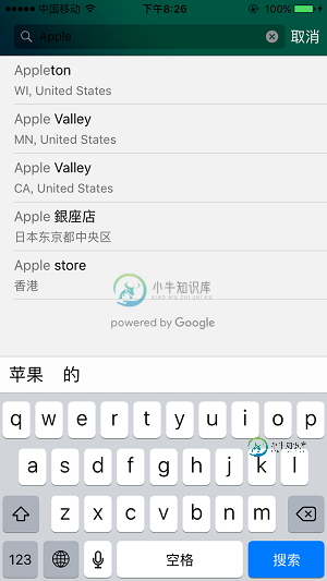
搜索:
搜索功能在官方文档是叫做“自动完成”,即你输入一部分的文本,GoogleMap会根据你的文本预测出地点并自动填充返回,具体请看官方文档自动完成
效果如图:
这里你需要做的步骤跟做“定位”的一样:
(1)获取APIKEY
(2) 在application:didFinishLaunchingWithOptions: 注册密匙
1[GMSPlacesClient provideAPIKey:@"YOUR_API_KEY"];
(3) 创建搜索UI并调用代理方法获取API自动填充的结果数组集
小坑提示: GMSPlacesClient跟GMSServices的密匙是不一样的,密匙不对的话,会出现反复调用
viewController:didFailAutocompleteWithError:的现象。
tips:搭建搜索UI又几种方式:1)搜索框直接创建在导航栏 2)搜索栏创建在视图顶部 3)自定义。根据你的需求用代码~
(一)这里是第一种方式(搜索框直接创建在导航栏):
GMSAutocompleteViewController *acController = [[GMSAutocompleteViewController alloc] init];
 acController.delegate = self;
 [self presentViewController:acController animated:YES completion:nil];
tips:这里就可以直接往搜索框编辑文字,API会直接给你返回搜索结果集合
(二)调用API代理方法:
// Handle the user's selection. 这是用户选择搜索中的某个地址后返回的结果回调方法
- (void)viewController:(GMSAutocompleteViewController *)viewController
didAutocompleteWithPlace:(GMSPlace *)place {

 [self dismissViewControllerAnimated:YES completion:nil];
 [self.marker.map clear];
 self.marker.map = nil;
 // 通过location 或得到当前位置的经纬度
 GMSCameraPosition *camera = [GMSCameraPosition cameraWithLatitude:place.coordinate.latitude longitude:place.coordinate.longitude zoom:Level];
 CLLocationCoordinate2D position2D = CLLocationCoordinate2DMake(place.coordinate.latitude,place.coordinate.longitude);
 self.marker = [GMSMarker markerWithPosition:position2D];
 self.mapView.camera = camera;
 self.marker.map = self.mapView;

 self.locationLabel.text = place.name;
 self.locationDetailLabel.text = place.formattedAddress;

}
tips:这个代理方法实现的是,当用户在搜索集中选择了在某一个结果返回地图,并定位添加大头针。
自动填充失败的回调:
- (void)viewController:(GMSAutocompleteViewController *)viewController
didFailAutocompleteWithError:(NSError *)error {
 [self dismissViewControllerAnimated:YES completion:nil];
 // TODO: handle the error.
 DLog(@"Error: %@", [error description]);
}
tips:自动填充失败后你可以在这里做一些事,默认是不管的。
补充:搜索栏的外观是可以自定义的,你可以设置成跟自己的app一样的风格~具体请看设置 UI 控件样式属性
到这里,搜索功能就算完成了。
-
本文向大家介绍详解iOS中集成ijkplayer视频直播框架,包括了详解iOS中集成ijkplayer视频直播框架的使用技巧和注意事项,需要的朋友参考一下 ijkplayer 是一款做视频直播的框架, 基于ffmpeg, 支持 Android 和 iOS, 网上也有很多集成说明, 但是个人觉得还是不够详细, 在这里详细的讲一下在 iOS 中如何集成ijkplayer, 即便以前从没有接触过, 按着
-
一、简介 Storm-Redis 提供了 Storm 与 Redis 的集成支持,你只需要引入对应的依赖即可使用: <dependency> <groupId>org.apache.storm</groupId> <artifactId>storm-redis</artifactId> <version>${storm.version}</version> <typ
-
集成样例代码 可以在这里获取集成样例代码https://github.com/finogeeks/mop-ios-demo (opens new window) 1. 获取 SDK KEY 及 SDK SECRET 使用SDK需要申请 SDK KEY 及 SDK SECRET ,只有在SDK初始化的时候配置了正确的 SDK KEY 及 SDK SECRET ,才能初始化成功并正常使用。 1.1 创
-
本文向大家介绍详解spring与shiro集成,包括了详解spring与shiro集成的使用技巧和注意事项,需要的朋友参考一下 Shiro的组件都是JavaBean/POJO式的组件,所以非常容易使用Spring进行组件管理,可以非常方便的从ini配置迁移到Spring进行管理,且支持JavaSE应用及Web应用的集成。 在示例之前,需要导入shiro-spring及spring-context依
-
本文向大家介绍详解spring boot集成RabbitMQ,包括了详解spring boot集成RabbitMQ的使用技巧和注意事项,需要的朋友参考一下 RabbitMQ作为AMQP的代表性产品,在项目中大量使用。结合现在主流的spring boot,极大简化了开发过程中所涉及到的消息通信问题。 首先正确的安装RabbitMQ及运行正常。 RabbitMQ需啊erlang环境,所以首先安装对应版
-
1. 配置*-info.plist文件 添加用户打开APP的URL Scheme 添加一个叫URL types的键值 添加一个叫URL types的键值。 点击左边剪头打开列表,可以看到Item 0,一个字典实体。 点击Item 0新增一行,从下拉列表中选择URL Schemes,敲击键盘回车键完成插入。 更改所插入URL Schemes的值为DeepShare配置中生成的Scheme。 2. 配