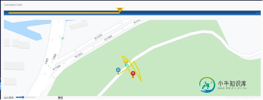
Vue+Openlayers自定义轨迹动画
本文实例为大家分享了Vue+Openlayers实现轨迹动画的具体代码,供大家参考,具体内容如下
<template> <div class="map-warp"> <h3> <a href="https://openlayers.org/en/latest/examples/feature-move-animation.html?q=polyline" target="_bank" >OpenlayersTrack</a> </h3> <div class="progress-bar"> <div class="bar-box"> <div class="bar" :style="{width:progress+'%'}"> <span>{{progress}}%</span> </div> </div> </div> <div id="map" class="map"></div> <el-row :gutter="20"> <el-col :span="5"> <label for="speed"> 运动速度: <input id="speed" type="range" step="10" value="5" /> </label> </el-col> <el-col :span="5"> <button @click="handlerPlay">{{textContent}}</button> </el-col> </el-row> </div> </template> <script> import "ol/ol.css"; import Feature from "ol/Feature"; import Map from "ol/Map"; import View from "ol/View"; import Polyline from "ol/format/Polyline"; import { Projection } from "ol/proj"; import { Point, LineString } from "ol/geom"; import { Tile as TileLayer, Vector as VectorLayer } from "ol/layer"; import XYZ from "ol/source/XYZ"; import VectorSource from "ol/source/Vector"; import { Circle as CircleStyle, Fill, Icon, Stroke, Style, Text } from "ol/style"; import { getVectorContext } from "ol/render"; export default { data() { return { map: null, progress: 0, // 进度 animating: false, // 动画是否开始 speed: null, // 速度 now: null, // 当前时间 textContent: "开始", routeCoords: null, // 数组点集合 routeLength: null, // 数组长度 route: null, // 线 routeFeature: null, // 画线 geoMarker: null, // 标记 startMarker: null, // 开始标记 endMarker: null, // 结束标记 styles: { route: new Style({ // 线的样式 stroke: new Stroke({ width: 6, color: [237, 212, 0, 0.8] }) }), icon: new Style({ // 默认icon样式 image: new CircleStyle({ radius: 7, fill: new Fill({ color: "red" }), stroke: new Stroke({ color: "white", width: 2 }) }) }), geoMarker: new Style({ // 设置标记样式 image: new Icon({ anchor: [0.5, 1], // 偏移位置 // rotation: 0, // 旋转 // size: [52, 26], // 图标大小 src: require("@/assets/tx-icon-1.png") }) }), start: new Style({ // 设置开始标记样式 image: new Icon({ anchor: [0.5, 1], src: require("@/assets/rise.png") }) }), end: new Style({ // 设置结束标记样式 image: new Icon({ anchor: [0.5, 1], src: require("@/assets/end.png") }) }) }, vectorLayer: null, // 矢量图层 center: [118.835014569433, 32.08414190192472] // 中心点 }; }, methods: { // 初始化地图 initMap() { let that = this; that.routeCoords = [ [118.83476768752418, 32.08385299388422], [118.83491813875425, 32.08394894013734], [118.83504349233812, 32.08408332210981], [118.83504349233812, 32.08408332210981], [118.83512889261571, 32.083918456790876], [118.83517286002402, 32.083733744293006], [118.83496824937895, 32.084077663081935], [118.83490797978696, 32.08412326115879], [118.83489815812887, 32.08414025948315], [118.83488806541473, 32.084153465524956], [118.83488315718186, 32.08415572622981], [118.8348782482698, 32.0841596143537], [118.83485807031045, 32.08416812475921], [118.83484798473395, 32.08416424284437], [118.83483789451235, 32.08417148163059], [118.83483789122208, 32.08417934749756], [118.83489794089253, 32.084006273376524], [118.83490803262733, 32.08399523720106], [118.83491321591835, 32.08398700421235], [118.83491812613363, 32.083979861216235], [118.83491812890527, 32.08397308027895], [118.83492822118053, 32.0839606878946], [118.83493831179283, 32.08395236406387], [118.8349443113023, 32.08394818448314], [118.83494840317711, 32.0839421415609], [118.8349582198328, 32.08393707761024], [118.83495822192893, 32.08393192409512], [118.83495822314188, 32.083928940480945], [118.83495822600715, 32.08392188830153], [118.83496831727095, 32.08391193701643], [118.83496832133952, 32.083901901220244], [118.83497432325855, 32.083891754391544], [118.83497841676457, 32.083881642888024], [118.83498850812316, 32.083871420344074], [118.8349985986039, 32.08386336769408], [118.83499860472438, 32.08384817837085], [118.83500869639813, 32.08383714209293], [118.83500870130179, 32.083824936382825], [118.83501279510463, 32.08381401114558], [118.83501852555108, 32.08380088571361], [118.83502861687877, 32.08379066312818] ]; that.routeLength = that.routeCoords.length; that.route = new LineString(that.routeCoords); that.routeFeature = new Feature({ type: "route", geometry: that.route }); that.geoMarker = new Feature({ type: "geoMarker", geometry: new Point(that.routeCoords[0]) }); that.startMarker = new Feature({ type: "start", geometry: new Point(that.routeCoords[0]) }); that.endMarker = new Feature({ type: "end", geometry: new Point(that.routeCoords[that.routeLength - 1]) }); // that.endMarker.setStyle( // new Style({ // // image: new CircleStyle({ // // radius: 7, // // fill: new Fill({ color: "red" }), // // stroke: new Stroke({ // // color: "white", // // width: 2 // // }) // // }), // // image: new Icon({ // // src: require("@/assets/tx-icon-1.png") // // }), // // text: new Text({ // // text: '11133333333333333333333333333333333311', // // scale: 1.3, // // fill: new Fill({ // // color: '#000000' // // }), // // Stroke:new Stroke({ // // color: '#FFFF99', // // width: 3.5 // // }) // // }) // }) // ); that.vectorLayer = new VectorLayer({ source: new VectorSource({ features: [ that.routeFeature, that.geoMarker, that.startMarker, that.endMarker ] // 线、标记、开始标记、结束标记 }), style: function(feature) { // 如果动画处于活动状态,则隐藏标记 if (that.animating && feature.get("type") === "geoMarker") { return null; } return that.styles[feature.get("type")]; } }); this.map = new Map({ target: "map", layers: [ new TileLayer({ source: new XYZ({ url: "http://www.google.cn/maps/vt?lyrs=m@189&gl=cn&x={x}&y={y}&z={z}" }), projection: "EPSG:3857" }), that.vectorLayer ], view: new View({ projection: new Projection({ code: "EPSG:4326", units: "degrees" }), center: this.center, zoom: 19, minZoom: 2, maxZoom: 19 }) }); this.mapClick(); }, // 地图绑定事件 mapClick() { let that = this; this.map.on("click", function(event) { let feature = that.map.getFeaturesAtPixel(event.pixel); let pixel = that.map.getEventPixel(event.originalEvent); let coodinate = event.coordinate; // let temp = feature[0].geometryChangeKey_.target // Point if (feature.length > 0) { console.warn(feature[0].values_.type, 111); // console.warn(feature[0].get('geometryChangeKey'),9999999999) } }); }, // 运动轨迹开关 handlerPlay() { if (this.textContent === "暂停") { this.stop(false); } else { this.start(); } }, // 轨迹移动 moveFeature(event) { let vectorContext = getVectorContext(event); let frameState = event.frameState; if (this.animating) { let elapsedTime = frameState.time - this.now; let index = Math.round((this.speed * elapsedTime) / 1000); // 进度条 this.progress = Math.floor( ((100 / this.routeLength) * (this.speed * elapsedTime)) / 1000 ); if (index >= this.routeLength) { this.progress = "100"; this.stop(true); return; } let currentPoint = new Point(this.routeCoords[index]); let feature = new Feature(currentPoint); vectorContext.drawFeature(feature, this.styles.geoMarker); } // tell OpenLayers to continue the postrender animation this.map.render(); // 开始移动动画 }, // 开始动画 start() { if (this.animating) { this.stop(false); } else { this.animating = true; this.textContent = "暂停"; this.now = new Date().getTime(); let speedInput = document.getElementById("speed"); this.speed = speedInput.value; this.geoMarker.setStyle(null); // hide geoMarker 隐藏标记 // just in case you pan somewhere else this.map.getView().setCenter(this.center); // 设置下中心点 this.vectorLayer.on("postrender", this.moveFeature); this.map.render(); } }, // 停止 stop(ended) { this.progress = 0; this.animating = false; this.textContent = "开始"; let coord = ended ? this.routeCoords[this.routeLength - 1] : this.routeCoords[0]; let geometry = this.geoMarker.getGeometry().setCoordinates(coord); //remove listener this.vectorLayer.un("postrender", this.moveFeature); // 删除侦听器 } }, mounted() { this.initMap(); } }; </script> <style lang="scss"> #map { height: 500px; margin-top: 20px; } /*隐藏ol的一些自带元素*/ .ol-attribution, .ol-zoom { display: none; } .progress-bar { width: 100%; height: 30px; margin: 30px 0; background: url("~@/assets/bg-5.png") center bottom no-repeat; background-size: 100% 30px; position: relative; box-sizing: border-box; .bar-box { position: absolute; top: 10px; left: 30px; right: 30px; height: 10px; border-radius: 5px; background: #034c77; } .bar { height: 10px; border-radius: 5px; background: url("~@/assets/bg-6.png") 0 bottom repeat #ecc520; position: relative; span { width: 50px; height: 50px; line-height: 18px; font-size: 12px; font-weight: bold; text-align: center; position: absolute; color: #fe0000; top: -30px; right: -25px; background: url("~@/assets/bg-7.png") center 0 no-repeat; background-size: 100% 30px; } } } </style>

以上就是本文的全部内容,希望对大家的学习有所帮助,也希望大家多多支持小牛知识库。
-
我已经创建了一个JScrollbar(具有自定义UI)和一个JTextArea在JScrollPane中的J面板。我不想添加滚动条作为滚动窗格的水平滚动条,因为我希望能够定位它。 我尝试在滚动条上设置模型并将其添加到面板(见代码),但这不起作用——拇指的大小不正确(它总是横跨整个轨道),定位也不正确。 如何将滚动条链接到文本区域,以便拇指大小和行为正确,并且仍然能够设置滚动条的位置和尺寸? 谢谢!
-
轨迹信息为用户的浏览信息(比如首页、商品页、购物车、支付页、支付成功页等),只有调用轨迹方法,客服端的客服人员才能看到用户的浏览内容,提高服务质量。 > 参数说明: 一.标准集成方式 基本集成方式适用于在需要上传的轨迹的界面分别调用以下接口实现轨迹上传功能。 1.首页轨迹 /** 上报轨迹 @param pageName 当前页面名称 @param model 轨迹参数模型 */ NtalkerT
-
轨迹的集成 轨迹信息为用户的浏览信息(比如首页、商品页、购物车、支付页、支付成功页等),用户可以在以上页面调用轨迹方法,调用成功后,客服人员可以在客服端看到用户的浏览内容,同时可以做客户下单统计,有助提高服务质量。如果客户不需要做统计可以不传轨迹。 参数说明: 参数 类型 是否必传 说明 siteid String 是 企业id title String 是 用户浏览当前页的标题名称 pagele
-
点击轨迹记录面板的结束记录按钮: 在弹出来的名称输入框中,输入轨迹名称(默认名称为时间),点击确定,即可完成轨迹记录: 保存完成后,主界面中会展示此轨迹线,也可通过数据管理进行其他操作。
-
轨迹记录开始后,地图中会实时更新位置信息并在轨迹面板中更新当前的轨迹信息。 轨迹记录面板包括一些轨迹记录中的统计信息: 当前速度,来自GPS的实时速度; 平均速度,本次轨迹记录的总平均速度; 最高速度,本次轨迹记录的最快速度; 总里程,本次轨迹记录的总距离; 总时间,本次轨迹记录的总时间;
-
确保定位功能完善情况下(可参考文档内 2.3权限设置,2.4电源管理),点击主界面右下方的轨迹图标打开轨迹记录面板。 轨迹记录面板主要包含:当前速度、平均速度、最高速度、总里程、总时间、最高海拔、最低海拔、累计爬升、累计下降、航向、图表等。 点击下方开始按钮即可开启轨迹记录

